Results for location
Wallops Island, Virginia, USA
Next launch for this location
Next launch for this location
Wallops Island, Virginia, USA
Firefly Aerospace
Commercial • USA
Launch Area 0 A
Wallops Island
Oct 30 at 08:00pm
Launchpad time•-0500
Oct 31 at 12:00am
Your local time•+0000
Firefly Alpha Block 2
Launch vehicle
Get notification
24 hours before launch
Get notification
1 hour before launch
Note: For all launches the scheduled launch dates and times are subject to change due to weather, equipment, crew and other factors.
Mission description
The Investigation of Convective Updrafts (INCUS) is a NASA Earth science mission led by Colorado State University that will investigate the behavior of tropical storms in order to better represent these storms in weather and climate models. It consists of 3 SmallSats flying in tight coordination to study why convective storms, heavy precipitation, and clouds occur exactly when and where they form.
Each satellite will have a high frequency precipitation radar that observes rapid changes in convective cloud depth and intensities. 1 of the 3 satellites also will carry a microwave radiometer to provide the spatial content of the larger scale weather observed by the radars. By flying so closely together, the satellites will use the slight differences in when they make observations to apply a novel time-differencing approach to estimate the vertical transport of convective mass.
— INCUS
Livestream
Attending a launch in person
Launches can be viewed 12 kilometers away at NASA's visitor center for no cost. It has an excellent view and it's free but unfortunately entry isn't guaranteed since they don't offer bookings ahead of time. It's first-come-first-served at the door so come an hour early. It's only available as an option for daytime launches within their regular business hours.
This image shows NASA's recommended viewing areas, I've circled in pink my recommendations, scroll below for more details.
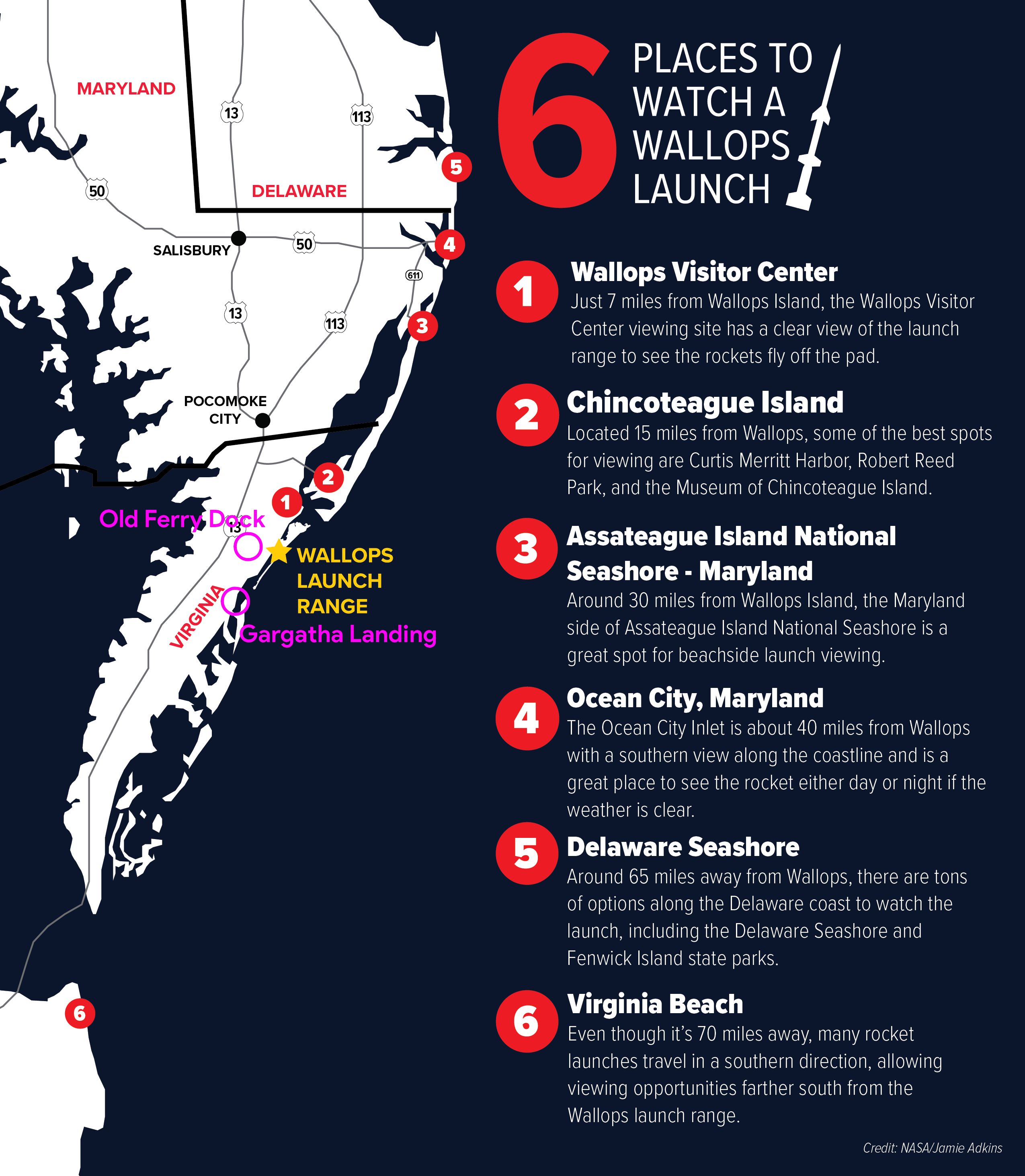
Image: NASA/Jamie Adkins
There are public spots available that are actually closer to the launchpads than the visitor center. The best alternative was previously Arbuckle Neck Road but that's been closed for safety reasons. Best now would probably be:
Old Wallops Island Ferry Dock: Closest public spot, about 4 kilometers from the launchpad (compared to 12 kilometers for their visitor center).
Gargatha Landing: 9 kilometers from the launchpad. A quieter spot.
How to get there
Accomodation
Nearby hotels in Chincoteague.
Nearby parking
Parking available on-site.
Agency details