Launch details
Firefly Alpha Block 2 | TacSat
Launch details
Firefly Alpha Block 2 | TacSat
Firefly Aerospace
Commercial • USA
Space Launch Complex 2W
Vandenberg Space Force Base
Dec 30 at 04:00pm
Launchpad time•-0800
Dec 31 at 12:00am
Your local time•+0000
Firefly Alpha Block 2
Launch vehicle
Get notification
24 hours before launch
Get notification
1 hour before launch
Note: For all launches the scheduled launch dates and times are subject to change due to weather, equipment, crew and other factors.
Mission description
First of up to 25 launches of Low Earth Orbit technology demonstration satellites to be built and operated by Lockheed Martin.
TacSat is an intelligence, surveillance and reconnaissance spacecraft with a mission to prove specialized sensing and communications capabilities on orbit. The satellite will participate in exercises that highlight cross-domain kill-web connectivity, enabling timely execution of tactical space missions.
TacSat will host a proven Lockheed Martin infrared sensor on board that brings previously developed technology to space for the first time. This sensor produces high quality imagery and it can interface with federated Battle Management Command & Control (BMC2) combat systems to provide joint forces with a comprehensive view of threats.
The satellite will also feature Lockheed Martin’s first 5G.MIL® payload on orbit. This provides cellular-like networking for military space assets, making satellite constellations more resilient. It also helps enable seamless connectivity with tools in the air, at sea and on land.
Launch operation will also again demonstrate responsive space pre-launch operation capabilities.
— TacSat
Livestream
Attending a launch in person
Viewing from the launch site is restricted to military and base personnel.
Public locations around the base provide excellent views, depending on weather.
Surf Beach: Best option for all launchpads if the marine layer keeps west, otherwise you'll get a poor view. Fills up fast on launch day. Closed from March to September to protect local wildlife and in the other months it'll sometimes be closed depending on launch trajectory.
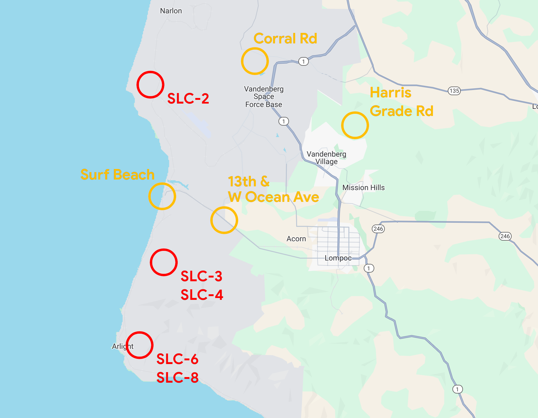
Corral Road: Good option for SLC-2. The semi-official viewing area. 8 kilometers away.
13th & W Ocean Ave: Good option for the southern pads. The hills and marine layer obstruct your view a bit but this is the closest you'll get, it's just outside the security checkpoint. There are a few other good intersections along W Ocean Ave (notably Renwick & W Ocean Ave).
Harris Grade Road: Alternative angle for all pads. It's up high on a hill and above the marine layer so you'll always have a view but it's much further away at 17 kilometers.
How to get there
Accomodation
Nearby hotels in Lompoc or Santa Maria.
Nearby parking
Parking available at the visitor center.
Agency details